
Last modified: 2020-08-08 by ian macdonald
Keywords: rio grande do sul | sertão santana |
Links: FOTW homepage |
search |
disclaimer and copyright |
write us |
mirrors
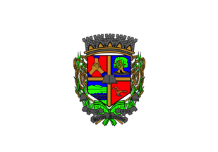 image by Ivan Sache,
6 August 2020
image by Ivan Sache,
6 August 2020
The municipality of Sertăo Santana (5,850 inhabitants in 2010; 25,161 ha) is
located 80 km south-west of Porto Alegre.
Sertăo Santana was settled in
1880 by French and Spanish colonists, on land originally granted in 1782 to
Domingo Ribeiro da Cunha by Viceroy Luiz de Vasconcelos e Souza. In 1892,
Commander Eduardo Secco initiated the organized colonization; the chapel of
Sant'Ana de Sertăo was consecrated on 28 October 1895.
The municipality of
Sertăo Santana was established by State Law No. 9,595 promulgated on 20 March
1992.
http://sertaosantana-rs.com.br/
Municipal website
Ivan Sache, 6 August 2020
A white flag bearing the municipal coat of arms centred.
Dirk Schönberger, 18 April 201
The flag and arms of Sertăo Santana are prescribed by Municipal Law No. 159
promulgated on 12 September 1995.
Article 2.
The coat of arms of the
municipality is described as follows.
German shield, quartered by a cross or
(gold) and charged in the center by a black open book, evoking religious
feeling, culture and emphasis put on education, respectively, which are
significant components of the life of the municipality's inhabitants.
In
chief dexter, on a background gules (red) a three-hands handshake or (gold),
recalling the origin of the municipality of Sertăo Santana, composed of former
parts of the municipalities of Tapes, Săo Jerônimo and Guaíba, as well as the
origin of the immigrants responsible of the colonization of the municipality.
In chief sinister, on a blue field, an umbu, a emblematic, big tree planted on
the town's main square, with a trunk argent and foliage vert (green),
symbolizing the rainforest reserve.
In counter-chief dexter, a fess azure
(blue) and a fess vert (green) symbolizing the topography of the region of the
municipality, located in Serra do Tapes, with three hills: Emboaba, Cutia and
Maravalha.
Fesses wavy azure (blue) and argent, symbolizing the water
resources of the municipality; a fess gules (red) referring to cattle-breeding,
the origin of the municipality's development.
In counter-chief sinister, on a
background gules (red) a plow argent and or (gold), representing agriculture,
mainly developed as small farms, which are one of the pillars of the
municipality's economy.
The shield surrounded dexter and sinister by plants
of rice or (gold) and vert (green). The shield placed on two crossed hoes or
(gold) representing the agricultural resources, fruit of the farmers' work.
The shield surmounted by a five-towered mural crown or (gold) and argent.
Beneath the shield, a three-part scroll argent inscribed in black Gothic letters
"24-03", "Sertăo Santana" and "1992", the municipality's day and month of
political emancipation, name, and year of emancipation. The scroll's border is
shaped like cogwheels, referring to the municipality's industrial activity.
Article 5.
The flag of the municipality has white for its official color.
Article 6.
The features of the flag obey the following rules.
I- The
flag's width is 14 units.
II - The flag's length is 20 units.
III - The
flag's center is charged with the coat of arms of the municipality.
http://sertaosantana-rs.com.br/bandeira-brasao/
Municipal website
Photos
https://www.facebook.com/sertaosantana2/photos/a.1463938950308688/2508104212558818/?type=3&theater
https://www.facebook.com/sertaosantana2/photos/a.2256061494429759/2256073524428556/?type=3&theater
Ivan Sache, 6 August 2020