
Last modified: 2020-07-31 by ian macdonald
Keywords: rio grande do sul | maquiné |
Links: FOTW homepage |
search |
disclaimer and copyright |
write us |
mirrors
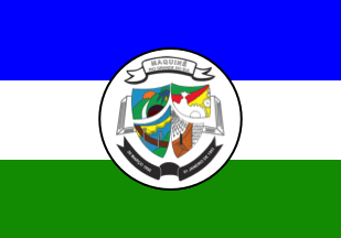 image by Ivan Sache, 31 July 2020
The municipality of Maquinķ (6,749 inhabitants in 2016; 62,212 ha) is located
150 km north-east of Porto Alegre.
Maquinķ was first settled in 1840 by
Ant¶nio Leonardo Alves, from the Abreu lineage. The first church was erected in
1900. In 1914, the establishment of a small port near Leonardo's fazenda caused
the place's name to be changed to Porto Cachoeira (Waterfall's Port). The
adoption in 1938 of the name of General Daltro Filho caused political troubles,
which were settled in 1940 by renaming the town to the more neutral name of the
river, Maquinķ.
https://maquine.rs.gov.br/
Municipal website
Ivan Sache, 31 July 2020
The flag of Maquinķ is prescribed by Municipal Law No. 41 promulgated on 31
August 1993.
Article 1.
The flag of the municipality of Maquinķ shall
have for official colors blue, white and green, representing:
a) Green, the
natural resources of the Maquinķ Valley, as well as its hills and orchards;
b) White, peace that should reign in the municipality;
c) Blue, the sky,
rivers, lakes, waterfalls and lagoons of the municipality.
In the center of
the white stripe shall be placed the coat of arms of the municipality.
https://leismunicipais.com.br/a/rs/m/maquine/lei-ordinaria/1993/5/41/lei-ordinaria-n-41-1993-institui-a-bandeira-como-simbolo-do-municipio
Leis Municipais database
The coat of arms of Maquinķ is prescribed by
Municipal Law No. 40 promulgated on 31 August 1993.
Article 1.
A
shield divided into four parts, superimposed to an open book. In the upper
stripe is highlighted the protection of the municipality, via a white scroll
inscribed in black with the name of the municipality, "MAQUIN╔", and of the
state, "ESTADO DO RIO GRANDE DO SUL".
In the first part, in the upper right
side, the natural beauties represented by the valley, the island, the waterfalls
and the forests; in the second part, in the upper left side, agriculture and
industry, represented by fields, a farmer and a tractor and cogwheels; in the
third part, in the lower right part, the municipality's traditions represented
by hanging bridges; in the fourth part, in the lower left part, economic
activities represented by orchards and pottery. The book on which the shield is
superimposed represents the political, historical, cultural, civic and social
features of Maquinķ's people. Beneath the shield a scroll inscribed with the
dates of political emancipation and inauguration of the municipality.
https://leismunicipais.com.br/a/rs/m/maquine/lei-ordinaria/1993/4/40/lei-ordinaria-n-40-1993-institui-o-brasao-como-simbolo-do-municipio-e-da-outras-providencias
Leis Municipais database
The municipal territory of Maquinķ includes
more than 10 waterfalls, most often of difficult, no signaled access, and
located on private properties. The Garapiß waterfall, located in Barra de Ouro,
15 km of Maquinķ downtown, falls down from a height of 12 m to a basin of 3 m in
depth. The Forqueta waterfall, also located in Barra de Ouro, falls down from a
height of 70 m.
http://g1.globo.com/rs/rio-grande-do-sul/nossa-terra/2012/noticia/2013/01/cascatas-do-garapia-e-da-forqueta-atraem-visitantes-maquine-rs.html
G1, 11 January 2013
Photos
https://www.facebook.com/pmmaquine/photos/a.230044430784955/420391038416959/?type=3&theater
Ivan Sache, 31 July 2020