
Last modified: 2020-07-12 by ian macdonald
Keywords: rio grande do sul | arroio grande |
Links: FOTW homepage |
search |
disclaimer and copyright |
write us |
mirrors
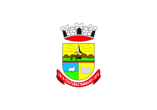 image by Ivan Sache, 11 July 2020
The municipality of Arroio Grande (18,748 inhabitants; 2,518.5 sq. km) is
located in the Pampa region, close to the border with Uruguay. According to
Statutory Law No. 441 of 25 July 1961, the municipality is made of Arroio Grande
(seat) and of the districts of Mauá, Pedreiras and Santa Isabel do Sul.
Arroio Grande was originally settled by a Manuel Jerônimo, probably Manuel Jerônimo de Souza, the grandfather of the Baron of Mauá. In 1812,
Manuel de Souza Gusmão and his wife Maria Pereira das Neves offered a plot of
land to build a chapel and a small settlement. The tradition says that there
was some debate on the site were the new settlement would be built along
brook ("arroio") Grande; the left bank was eventually preferred to the right
one. The chapel dedicated to Our Lady of Grace was erected on 14 December
1815 and confirmed on 15 April 1821 by King John VI. Several battles of the
War of the Ragamuffins occurred near Arroio Grande. Provincial Law No. 54
of 26 May 1846 made of Arroio Grande the 39th parish of the State. Law No.
596 of 2 January 1867 divided the municipality of Jaguarão into five
districts, including Arroio Grande as the 2nd district. Law No. 843 of 24
March 1873 made of Arroio Grande a "vila", upgraded to a "cidade" by Law No.
590 of 5 November 1890, under the brand new name of Federação, quickly
reverted to Arroio Grande by Law No. 522 of 6 July 1891.
The flag
is white with the municipal coat of arms in the middle.
The coat of arms
is in Portuguese shape, made of " a field and two quarters" (that is, divided
per fess with the base divided per pale). The horizontal division of the
shield is made of a red stripe, symbolizing the sacrifice of the Arroio
Grande's citizens for the preservation of the integrity of the municipality.
The upper part of the shield shows on a yellow background a landscape
including a black tractor pulling a disc plough, a tribute to agriculture, in
front of a "coxilha" characteristic of the local topography. The Mauá obelisk
, standing on three steps (http://antares.ucpel.tche.br/turismodazonasul/upload/Image/arroiogrande/Obelisco_a_Maua.jpg - photo) is placed above the landscape. The lower left part
of the shield shows on a light blue field a white sheep standing on a green
terrace, as a tribute to sheep breeding, once the only source of progress for
the municipality. The lower right part shows on a yellow background an open
white book, as a tribute to the locals' aspiration to culture and
intellectual activities. The shield is surmounted by a white,
three-towered mural crown symbolizing the town status of Arroio Grande.
Below the shield is placed a red scroll charged with the white writing "1812
- CULTURA E TRABALHO - 1873". "1812" and "1873" recalls that Manuel de Souza
Gusmăo offered that year a plot of land on which the parish church dedicated
to Our Lady of Grace would be erected in 1873, considered as the year of
settlement of Arroio Grande.
Ivan Sache, 7 January 2012
Photo:
https://www.jornaltradicao.com.br/arroio-grande/geral/arroio-grande-decreta-situacao-de-calamidade-publica/
Ivan Sache, 11 July 2020
Official website at
http://www.arroiogrande.rs.gov.br/nova/index.php
Dirk Schönberger,
30 December 2011