
Last modified: 2020-07-12 by ian macdonald
Keywords: rio grande do sul | arroio do sal |
Links: FOTW homepage |
search |
disclaimer and copyright |
write us |
mirrors
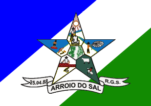 image by Ivan Sache, 11
July 2020
image by Ivan Sache, 11
July 2020
The municipality of Arroio do Sal (6,635 inhabitants in 2007; 121 sq. km) is
located in northern Rio Grande do Sul, 170 km of Porto Alegre. It seceded from
the municipality of Torres on 22 April 1988 (State Law No. 8573).
Arroio
do Sal is located on the northern shore of Rio Grande do Sul, once a waste land
that the kings of Portugal allocated to different colonists. In the 19th-20th
centuries, the territory was divided into 70 municipalities. The first settled
area in Arroio do Sal was the Eastern Estate, made of 17 communities. At the
time, the locals lived from agriculture, cattle-breeding and fishing in Lake
Itapeva, a coastal laguna. Until the mid 1920s, they did not fish in the sea,
which was located 6 km from the village and separated from them by dunes and
marshes. A courageous villager once went to the sea and came back to the
village, explaining that the sea was rich in fish and seafood. Several villagers
followed his tracks, building huts on the beach, where they would stay for the
next two weeks. In 1939-1940, the Second World War caused a shortage of salt.
Some fishers living near the lake moved to the bank of the river, where they
extracted salt from the sea water. In 1939, a shepherd from Santa Catalina built
a house and became the first permanent inhabitant of Arroio do Sal.
Ivan Sache, 12 January 2012
Diagonally divided blue over green by a white bend sinister, overlain by the municipal arms in the centre.
Official website at
http://www.arroiodosal.rs.gov.br
Dirk Schönberger,
29 December 2011
The
municipal symbols are prescribed by Article 1 of Municipal Law No. 16 of 10
April 1989, as follows.
Article 1.
I. The municipal coat of arms shall
have the following the characteristics:
a. The shield is outlined in black,
of 70 cm x 70 cm.
b. The inner part of the shield is divided into six
quarters, the upper one with a yellow sun shining down on the urban area and the
blue sea. In the lower part on the bank of a blue brook ("arroio") a white
villager outlined in black producing salt ("sal") in a can placed on a fire.
This quarter represents the origin of the name of the municipality.
c. The
upper right part of the star shows a blue sea with a white fisher outlined in
black throwing his white net outlined in black. This quarter represents fishing
activity on the coast.
d. The lower right part of the star, green, represents
agriculture and cattle-breeding; it is charged with a bovine and a horse, both
white outlined in black, representing the commitment to preserve traditions.
e. The lower left point, white, yellow and green, represents the building of the
town; it shows a villager erecting a brick wall.
f. The upper left point,
black, blue and red, shows a blue sea with a surfer on a black, white and red
surfboard, as well as a sunbather protected by a black, white and red beach
umbrella, representing tourism.
g. The central part is green, white and red,
with in its left part a maize plant representing agriculture.
h. Below the
shield is placed a scroll with the writing "25.04.88 – ARROIO DO SAL – R.G.S",
the date of foundation of the municipality.
II. The municipal flag shall
have the following characteristics:
a. A dimension of 16 modules (112 cm) on
22 modules (154 cm).
b. The division if for calculation of squares modules.
c. The colors of the flag are those of the coat of arms, also the official
colors of the municipality, that is, blue, red, green, yellow, and black.
d.
The flag is made of the coat of arms placed on a white, blue and green
background.
e. The placement of the colors is the following, a diagonal
stripe starting from the lower left corner and reaching the upper right corner,
of 35 cm in width.
f. The upper left part is blue.
g. The lower right
part is green.
h. The coat of arms is placed in the central area of the flag.
http://www.arroiodosal.rs.gov.br/index.php?secao=secao&mostraconteudo=64
Ivan Sache, 12 January 2012
Photos:
http://aracysegundoanoa2.blogspot.com/2014/04/simbolos-do-arroio-do-sal.html
http://aracysegundoanoa2.blogspot.com/2015/11/texto-coletivo.html
http://aracysegundoanoa2.blogspot.com/2017/04/aniversario-do-municipio.html
Ivan Sache, 11 July 2020