
Last modified: 2020-07-12 by ian macdonald
Keywords: rio grande do sul | aceguá |
Links: FOTW homepage |
search |
disclaimer and copyright |
write us |
mirrors
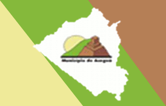 image by Dirk Schönberger, 19
December 2011
image by Dirk Schönberger, 19
December 2011
Source:
http://www.acegua.rs.gov.br/portal1/municipio/hino_brasao.asp?iIdMun=100143468
The municipality of Aceguá (4,731 inhabitants in 2016; 15,496 ha) is located
on the border with Uruguay, 430 km south-west of Porto Alegre. Known as "Border
Princess", Aceguá forms a single urban unit with its Uruguayan counterpart, also
named Aceguá (1,511 inh. in 2011).
The municipality of Aceguá was
established on 16 April 1996, separating from Bagé, but inaugurated only on 1
January 2001.
Ivan Sache, 11 July 2020
The symbols of Aceguá are prescribed by Municipal Law No. 88 promulgated on
15 February 2002.
Article 2.
The logomark is represented by three
symbols superimposed on three distances.
I. The foreground features the
milestone indicating the Brazil-Uruguay border, in ceramic color (tile color),
with two shades.
II. The middle distance represents a green hill, symbolizing
Aceguá's hill.
III. The background features a sun, symbolizing municipal
progress and development.
Article 3.
The logomark shall be composed of
the three symbols, in proportions twice longer than wide, standing on a black
horizontal line, beneath the writing "Municipio de Aceguá".
The text shall
follow the Futura Md BT typography.
Article 4.
The colors of the
logomark are codified on the Pantone 280 scale CV as follows:
I. Chalk yellow
- 2C, 3M, 46Y
II. Chartreuse - 45C, 2M, 98Y
III. Brownish red - 17C, 48M,
68Y
IV. Brick - 36C, 72M, 77Y, 1K
V. Black - 82C, 73M, 73Y, 91K.
Article 5.
The municipal flag is in rectangular shape and has three basic
colors: yellow, green and light brown.
§1. The flag is composed, primarily,
of a yellow right-angle triangle, the hypotenuse facing upwards, starting in the
panel's upper corner.
§2. In the center, a green lozenge [a parallelogram]
with the distant points in the flag's upper and lower points.
§3. The third
part of the flag, triangular, light brown, in the same dimensions as the first
triangle, its inverted shape ending in the panel's lower corner.
§4. In the
flag's center, superimposed on the lozenge, the perimeter of the map of the
municipality, white outlined in black.
§5. In the center of the
aforementioned map, the logomark in proper dimensions and colors.
https://leismunicipais.com.br/a/rs/a/acegua/lei-ordinaria/2002/9/88/lei-ordinaria-n-88-2002-institui-os-simbolos-do-municipio
- Leis Municipais database
Oddly enough, the monument represented on the
logomark of Aceguá appears to be white-washed.
Photo:
https://commons.wikimedia.org/wiki/File:Aceguá,_Departamento_de_Cerro_Largo,_Uruguay_-_panoramio.jpg
Ivan Sache, 11 July 2020