
Last modified: 2020-08-08 by ian macdonald
Keywords: rio grande do sul | pinheiro machado |
Links: FOTW homepage |
search |
disclaimer and copyright |
write us |
mirrors
 image
by Ivan Sache, 2 August 2020
image
by Ivan Sache, 2 August 2020
The municipality of Pinheiro Machado (12,780 inhabitants in 2010; 22,496 ha)
is located 270 km south-west of Porto Alegre.
Pinheiro Machado, one of
Rio Grande do Sul's oldest municipalities, was transferred in 1830 from Rio
Grande to the newly established municipality of Piratini.
The settlement
originates in a camp established by travelers near a natural well ("cacimba"),
soon organized as the village of Cacimbinhas. The chapel dedicated to Our Lady
of the Light was erected on a plot offered on 10 April 1851 by Dutra de Andrade,
who had miraculously recovered vision after having poured water from the well on
his eyes. The settlement was administratively organized by Law No. 215
promulgated on 10 November 1851. Elevated to a parish in 1857, Nossa Senhora da
Luz das Cacimbinhas was granted municipal status, as Cacimbinhas, on 24 February
1879.
Cacimbinhas was renamed to Pinheiro Machado upon order of Provisional
Intendent Ney Lima Costa, after Senator Josť Gomes Pinheiro Machado (1851-1915;
known as the Constable of the Republic) had been murdered in Rio de Janeiro by
Francisco Manso de Paiva Coimbra, an inhabitant of the region of Cacimbinhas.
The name change did not please the local population, who expelled the intendent
from the town.
http://www.pinheiromachado.rs.gov.br/
Municipal website
Ivan Sache,
2 August 2020
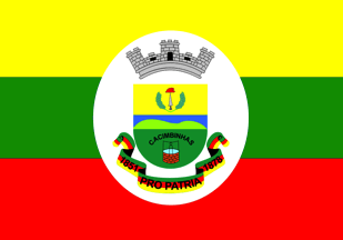
The flag of Pinheiro Machado is a yellow-green-red horizontal tricolor, with a central white oval bearing the municipal arms.
The origin of the town is recalled in the shield's lower part by the well ("cacimba")
around which the town of Cacimbinhas developed.
Image from the municipal
website
http://www.pinheiromachado.rs.gov.br/hinos-e-simbolos/
Ivan Sache, 2 August 2020