
Last modified: 2011-02-05 by ian macdonald
Keywords: minas gerais | rubim |
Links: FOTW homepage |
search |
disclaimer and copyright |
write us |
mirrors
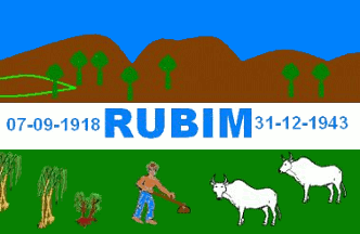 image by
Dirk Schönberger, 2 September 2010
image by
Dirk Schönberger, 2 September 2010
Source:
adapted from
http://madeinrubim.blogspot.com/2008/12/informes-sobre-o-munpio.html
The flag depicts an agrarian scene with some trees on a brown hillside in the background, some crops, zebu cattle and a man hoeing in the foreground, and between them a white band stating 07-09-1918 RUBIM 31-12-1943.
No official website found.
Dirk Schönberger,
2 September 2010
The municipality of Rubim (9,561 inhabitants in 2009; 969 sq. km) is located
on in north-eastern Minas Gerais. It is named for River Rubim do Sul. Rubim is
the birth place of the musician and singer Rubinho do Vale (see and listen, for
instance
http://www.youtube.com/watch?v=Nld6DbtqsIo).
The dates flanking the
municipality's name on the white stripe mean:
- 07-09-1918, the date of
erection of the village of Rubim, when the first houses used to store goods were
built;
- 31-12-1943, the date of municipal foundation and municipal day.
Ivan Sache, 3 September 2010