
Last modified: 2026-04-11 by  zachary harden
Keywords: colonial flag | weaving |
Links: FOTW homepage |
search |
disclaimer and copyright |
write us |
mirrors
Other sites:
In 1908, Portugal divided the Timorese territory into 15 military commands,
responsible for the decentralization of the civil administration. One decade
later, the Portuguese metropolis created the first circunscrições civis
(English: civil circumscriptions, a generic term for association of civilians)
which divided military power, since it had become superfluous after the signing
of the Arbitral Sentence (by the Permanent Court of Arbitration in 1914 with the
Netherlands. The first concelho (English: council, as in (municipal)
council) - Dili - was only created in 1940. After that, many other concelhos
(municipalities) and circunscrições (circumscriptions) coexisted,
until the last circumscription (Oecussi-Ambeno) was given the status of
concelho (municipality) in August 1973.
By the mid-1960s, the
Portuguese administration was organized into 11 municipalities:
The borders of these divisions were similar to those of present-day
distritos (English: districts); however, there are three differences:
the Municipality of Aileu was separated from Dili during the last years of
the Portuguese administration; and, under the Indonesian administration, the
subdistrict of Turiscai (located in Manufahi, formerly a part of the Ainaro
district, was transferred to Manufahi. As a result, Hato Udo (located in
Ainaro was taken from Manufahi and given to Ainaro. Among all of the
districts in Timor-Leste, Viqueque is the largest, with an area of 884 km²,
and Dili the smallest (364 km²).
Source:
http://timor-leste.gov.tl/?p=91&lang=en
Esteban Rivera, 25 April 2017
In 2015 Timor-Leste changed its districts into municipalities. Since then
there were some symbols adopted. I could detect logos of the municipalities of
Aileu and Cova Lima (Tetum and Portuguese versions), a flag of Manufahi and
logos and flags of the Autoridade da Região Administrativa Especial de Oecusse
(ARAEO) and the Zona Espesial Ekonomiko Sosial no Merkadu (ZEESM), which
includes Oecusse(-Ambeno).
Flags of Oecusse can be seen in a photo at the
office of the president of ARAEO, Mr. Alkatiri:
https://www.facebook.com/photo.php?fbid=10207745954828967&set=g.213490025459127&type=1&theater
The full logos and the other images are collected at German Wikipedia:
https://de.wikipedia.org/wiki/Flagge_Osttimors#Flaggen_und_Symbole_der_Gemeinden_Osttimors
J. Patrick Fischer, 25 April 2017
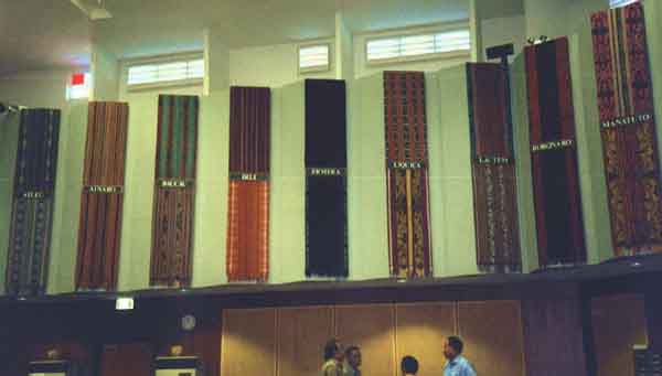
On the right and the left wall of the East Timor national parliament
are hanging traditional weavings,
each with the name of one of the districts. Each district has such a weaving
on the left and the right, but there are not exactly the same, just similar.
So, not regional flags, but examples of traditional designs of each
district?…
J. Patrick Fischer, 08 August 2002
A set of flag images purporting to represent the "Districts of East Timor" is posted on Wikimedia commons at http://commons.wikimedia.org/wiki/Category:Flags_of_districts_of_East_Timor. These images were drawn by J. Patrick Fisher for internal use in FOTW and (although they were forwarded to the government in East Timor) have not been adopted to our knowledge by any of the districts.
I never saw my images in official use in TL and the districts are still not
changed into municipalities with their own elected administrations. The
administrators are still nominated by the central government, so I can not see
any local authority which could use "my" flags.
J. Patrick Fisher,
10 January 2012
I just heard it in the radio: the CNRT, meeting in Darwin, Australia, issued a first draft of the future administrative division of the future independent republic of Timor Lorosae. The 13 municipalities [districts] are maintained in principle, but the territory will be divided into 3 provinces (handled by the CNRT as economical planning regions), a northern province including Díli but excluding Atauro and Ocussi Ambeno, a Eastern province including Baucau and the eastern half of the territory and a southern province including the southern coast. The provinces would include:
So, in the future Republic of East Timor, if this plan is implemented, the following flags are to be expected:
I’ll not be surprised if both municipalities and
communes are to be changed in near future. I guess
the flags from the Portuguese era (unused in the
last 25 years) will not be revived.
António Martins, 23 October 1999
Well, they might. The majority of the Timorese are
in a state of nostalgia for everything Portuguese so
they just might dig up the old municipal flags, at least
to serve as basis for new ones. Anyway, the
CNRT proposed to the UN the
organization of local elections within one year, so these
flags would possibly be used only after that.
But everything is highly speculative here.
Jorge Candeias, 27 October 1999
The four parts [symbolized on the U.D.T. flag] of the territory are:
As far as I know, the Indonesian occupation didn’t change the limits of the territory (one might ask why…), all those three territories [Jaco, Ocussi-Ambeno and Ataúro] being considered by the Indonesian government as parts of “their” 27th province Timor Timur. This border line, by the way, was settled between Portugal and the Netherlands very early in the 20th cent., if I recall correctly by swapping the vassal-dom of several native kingdoms along the border area, previously the territorial claims were a mess of enclaves and exclaves.
It might be of interest to say that
Oecussi-Ambeno (a coastal enclave to the SW) is
one of the 13 districts, Ataúro/Kambing (an island some 20 km north of Dili)
is/was one of the communes of the Dili district,
and Jaco (a very small islet, probably uninhabited) is/was a part of the
Lautém district, Tutuala commune.
António Martins, 22 August 1999
Island Ataúro was recently (2022) detached from
Díli mun. to become a separate municipality. No news, for now, about a
putative municipal flag.
António Martins-Tuválkin, 05 March 2026
 image by J.
Patrick Fischer, 10 January 2012
image by J.
Patrick Fischer, 10 January 2012
The image above represents a compendium of flag proposals for the districts of Timor Leste, drawn by J. Patrick Fischer and submitted to the Timor Leste government, although with no response. They were subsequently posted on the internet by Mr. Guterres, who provided them for Wikipedia, where they are now posted as flags of the districts (linked from https://en.wikipedia.org/wiki/Districts_of_East_Timor).
I never saw "my" images in official use in TL and the districts are still not changed into municipalities with
their own elected administrations. The administrators are still nominated by the central government, so I can not see any local authority which could use "my" flags.
J.
Patrick Fischer, 10 January 2012