
This page is part of © FOTW Flags Of The World website
Dantumadeel (The Netherlands)
Fryslân province
Last modified: 2024-01-20 by rob raeside
Keywords: dantumadeel |
Links: FOTW homepage |
search |
disclaimer and copyright |
write us |
mirrors
 Shipmate Flagchart : http://www.flagchart.net
adopted 22 Mar 1962
Other Dantumadeel pages:
See also:
Dantumadeel municipality
Population (1 January 2004): 19.762; area: 87,00 km²; settlements: Damwoude
(seat, incl. Murmerwoude (former seat), Akkerwoude,
Dantumawoude), Broeksterwoude,
De Valom, Driesum,
Rinsumageast, Roodkerk,
Sijbrandahuis, Veenwouden,
Veenwoudsterwal, Wouterswoude, Zwaagwesteinde.
The municipality of Dantumadeel/Dantumadiel is in northeast Friesland/Fryslân
(Netherlands), just south of the city of Dokkum.
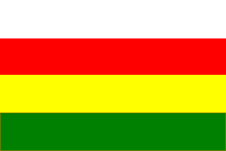
The flag is derived from the municipal Coat of Arms. Yellow for the sandy soil.
Green for the forests ('wâlden') - don't know about the other colors.
Jarig Bakker, 21 August 1999
Dantumadeel: Flag: "Four stripes white-red-yellow-green," established
22 Mar 1962.
The shield is: Divided per pale in three parts of red, gold and green,
parted by a wavy bar silver, the gold charged with a jumping fox red.
Franc van Diest, 10 October 2000
Dantumadeel Coat of Arms
dd.gif) International
Civic Arms : http://www.ngw.nl/heraldrywiki/index.php?title=Dantumadeel
International
Civic Arms : http://www.ngw.nl/heraldrywiki/index.php?title=Dantumadeel