
Last modified: 2024-07-13 by daniel rentería
Keywords: azuay | santa isabel |
Links: FOTW homepage |
search |
disclaimer and copyright |
write us |
mirrors
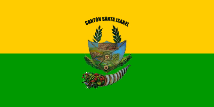 image by Jens Pattke, 3 October 2008
![]() - indicates
a flag is known..
- indicates
a flag is known..
![]() - indicates it is reported there is no flag.
- indicates it is reported there is no flag.
★ - indicates the cantonal capital
Parishes:
|
See also:
Santa Isabel Canton flag.
Source: www.santaisabel.gov.ec.
Jens Pattke, 3 October 2008
Santa Isabel canton (18,393 inhabitants in 2010; 77,141 ha) is located in the
south of Azuay province, in the upper and middle valley of river Jubones.
Ivan Sache, 6 September 2018
Santa Isabel canton (18,393 inhabitants in 2010; 77,141 ha) is located in the
south of Azuay province, in the upper and middle valley of river Jubones.
The flag of Santa Isabel is composed of two horizontal stripes of equal
dimensions, green and yellow. Green, placed in the upper part of the flag, is a
symbol of soil fertility, of agricultural productivity and of green pastures.
Yellow, placed in the lower part of the flag, is a symbol of the canton's
resources, of the sunny valley, and of the climate's freshness.
The coat
of arms of Santa Isabel includes a shield divided by chains forming a saltire.
In the center, a disk with the sun represents the old deities venerated by the
early inhabitants. Above are the ruins of the Cañaribamba fortress. In base, a
mill wheel and plants of coffee and sugar cane represent the parish of Abdón
Calderón. On the left side are represented mountains and river Jubones that
crosses the canton's territory. On the right side, wheat is the symbol of the
parish of Shaglli.
The shield is surmounted by two branches of olive, symbolizing peace. Beneath
the shield, a cornucopia symbolizes wealth as the product of work and of the
forces of these noble people.
https://issuu.com/revistacuencailustre/docs/santa_isabel_2012
Santa
Isabel. Turismo & Cultura. 2012.
Ivan Sache, 6 September 2018