
Last modified: 2019-10-14 by bruce berry
Keywords: namibia | walvis bay |
Links: FOTW homepage |
search |
disclaimer and copyright |
write us |
mirrors
 image
by Martin Grieve, 12 Oct 2019
See also:
image
by Martin Grieve, 12 Oct 2019
See also:
The town's name is Walvis Bay in English
and Walvisbaai in Afrikaans. The bay was named in its first annexation by the Dutch in
the time of Jan van Riebeeck, but the annexation was a dead letter and
the bay was never occupied by the Dutch. The bay quite possibly got its
name from one of the ships in Van Riebeeck’s fleet, which was called Walvis.
The name was also given to one of the four bastions of the Fort de Goede
Hoop which Van Riebeeck built.
The bay was annexed by Britain in 1878 and became part of the
Cape
Colony in 1884. The extent of the Walvis Bay territory was 1 124 km2 ,
much of it desert but including an important wetland south of the main
bay at Sandwich Bay. It was intended that further territory in the vicinity
would be annexed in due course, since the area fell into the British "sphere
of influence". However Britain was outmaneuvered by Germany, when in 1892
it acknowledged Lüderitz's treaties with local chiefs and made further
annexations along the coast. German maps referred to the bay as "Walfischbucht",
and since these were often seen in South Africa and South West Africa,
it was often imagined that the German name was actually in use at some
point in time. There are references to "Walfisch Bay" or even "Wallfish
Bay", a totally spurious name.
On 01 October 1922 Walvis Bay was – for all practical purposes – handed
over to the administration of the Mandated Territory of South West Africa
(formed in January 1921), although in terms of international law it remained
part of South Africa and the Cape Province. On 30 August 1977 the Cape
Province again became responsible for the administration of Walvis Bay.
For parliamentary electoral purposes it was at first part of the constituency
of Sea Point (in Cape Town), and later of Namaqualand. (The Sea Point constituency,
when it included Walvis Bay, also included the guano islands along the coast.
Some of these are still part of South Africa, but several of them were
off the coast of South West Africa/Namibia.)
Following Namibian independence in 1990, agitation arose for Walvis Bay to
be handed over to that country began. This was finally done by the
National Party government of South
Africa in 1993. The guano islands north of the Orange River were handed over
at the same time.
Mike Oettle, 18 Dec 2001
The historical overview of the political situation regarding Walvis Bay is as follows:
12 Mar 1878 - Walvis Bay becomes a British Protectorate
07 Aug 1885 - Incorporated into the Cape Colony
31 May 1910 - Becomes part of the Union of South Africa (along with
Cape Colony)
1922 - Administration of Walvis Bay assigned to South West Africa Mandate
by League of Nations
1977 - Walvis Bay re-integrated into South Africa (as part of the Province
of the Cape of Good Hope) ignoring the United Nations resolution
01 Mar 1994 - Walvis Bay ceded to Republic of Namibia by South Africa
South Africa no longer administers Walvis Bay, having ceded it to
Namibia
in 1994. When administered as part of South Africa, Walvis Bay did not
have its own flag.
Bruce Berry, 03 Dec 2001
The municipal flag of Walvis Bay has a white field with the municipal
arms in the centre, beneath which is the name of the town in
large black capital letters.
Valentin Poposki, 06 Sept 2019
wb1.jpg) image
sent by Bruce Berry, 12 Oct 2019
image
sent by Bruce Berry, 12 Oct 2019
Walvis Bay is the principle port of Namibia located on the Atlantic
Coast. Until March 1994 the town was part of South Africa and administered
as part of the former Cape Province of South Africa.
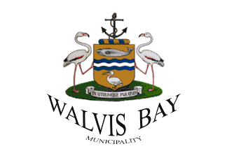
The Municipal Arms were
originally granted by the then Administrator of South West Africa on 01
December 1964 and later registered with the South African Bureau of Heraldry
on 30 October 1967. The Arms are described as:
ARMS: Or, on a fess wavy Azure a barrulet way Argent, in chief a whale
and in base a pelican, both proper
CREST: An anchor cabled erect, Sable
WREATH AND MANTLING: Or and Azure
SUPPORTERS: Two flamingos proper
MOTTO: IN UTRUMQUE PARATUS (Prepared for Either).
Bruce Berry, 24 May 2001