
Last modified: 2022-03-05 by ian macdonald
Keywords: parana | ibema |
Links: FOTW homepage |
search |
disclaimer and copyright |
write us |
mirrors
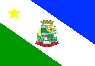 image by Ivan Sache, 3 February 2022
Image from the municipal website
https://www.pibema.pr.gov.br/pagina/simbolos-do-municipio
The municipality of Ibema (6,066 inhabitants in 2010; 14,544 ha) is located
470 km west of Curitiba.
Ibema was established in 1962 by Ibema Indústria
Brasileira de Madeiras S/A, on plots located along strategic road BR 277, which
were acquired from Grupo Camargo. In 1966 Ibema S/A/ acquired from Camargo the
Formiga sawmill. Camargópolis, the settlement established in 1956 by Francisco
Natal de Camargo was renamed to Ibema.
The district of Ibema was established
by State Law No. 5,358 promulgated on 24 June 1966, to be elevated to a
municipality by State Law No. 9,007, promulgated on 12 June 1989, separating
from Catanduvas. The municipality was inaugurated on 1 January 1990.
https://www.pibema.pr.gov.br/
Municipal website
The flag of Ibema is
diagonally divided blue-white-green by a broad white stripe running from upper
hoist to lower fly, charged on top with a yellow star and in the center with the
municipal coat of arms.
https://www.pibema.pr.gov.br/pagina/simbolos-do-municipio
Municipal
website
Ivan Sache, 3 February 2022