
Last modified: 2021-08-25 by rob raeside
Keywords: condorcanqui | amazonas | peru |
Links: FOTW homepage |
search |
disclaimer and copyright |
write us |
mirrors
Province of Condorcanqui is in Amazonas Region, Peru.
It has about 47 000 inhabitants on 17 865 km². Its flag
is shown in provincial
website.
Valentin Poposki, 24 Sep 2007
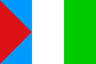
It is a quite original design,
yet fully composed of classical usual vexillographic elements (albeit
countering the heraldic rules of colors):
A vertical tricolor of blue, white and green, the blue area
containing a tangent red (?) hoist triangle — its base coinciding with
the flag's hoist edge and the apex with the midpoint of the
blue-white boundary. Approximate ratio: 2:3; shade of blue apparently
light.
António Martins, 24 Sep 2007
The flag was designed by Juan Alberto Torres Linares. Red recalls the blood
shed in the different armed conflicts with Ecuador* ; the point of the red
triangle touching the white field, synonym of peace, means that peace and
friendship have been reestablished and that we don't want to shed more blood for
unnecessary reasons. Light blue represents the water resources of the region.
White means eternal peace. Green represents the Amazonian forest.
The flag should be hoisted on a golden hoist, representing the resources in
timber and gold of the province.
Source:
http://municondorcanqui.gob.pe/himno.php >
* The Province of Condorcanqui was involved in a long-running territorial
dispute between Peru and Ecuador. The Ecuadorian-Peruvian War (5-31 July 1941)
ended with a Peruvian victory and the signature of the Rio Protocol (29 January
1942), which did not prevent another two conflicts to break out, the Paquisha
War (January-February 1981) and the Cenepa War (26 January - 28 February 1995.
The dispute was, hopefully, settled with the Final Peace Agreement signed on 26
October 1998, restoring the borders fixed by the Rio Protocol.
Ivan Sache, 29 May 2010