
Last modified: 2026-06-27 by martin karner
Keywords: gderot | regional council | mo'atza ezorit gderot |
Links: FOTW homepage |
search |
disclaimer and copyright |
write us |
mirrors
See also:
Regional Council Gderot ["the fences"] is situated north to Ashdod–Gedera
road (road 41) and it is named after Gedera, a city in Judah tribe estate (Joshua 15:41
– see also Local Council of Gadera) which
also gave it the lion in its emblem (Judah's symbol). Est. 1953,
pop. 3250. In my visit there was no flag. I was told the logo on
several bedsheets is used on occasions. I drew the flag as green
(the emblem main colour) with emblem, but this
flag is only probable. The municipal emblem was published in
the official gazette (Rashumot, Yalkut ha-Pirsumim), YP
633, 13 November 1958.
Source: author's own observation, 29 September 2001.
Dov Gutterman, 10 October 2001
I had one more visit but still no flag to report.
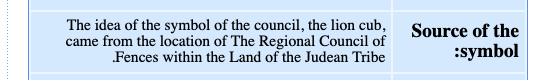
According to www.gderot.com [retrieved],
the ideas for the emblem of "Juda lion cub" came from
the position of the Regional Council in Juda tribe estate [screenshot transl.]. See
also: Flags of the Tribes of Israel.
The Regional Council governs seven settlements (Gan HaDarom,
Kefar Aviv, Kefar Mordekhai, Meishar, Misgav Dov, Aseret and
Shdema).
Dov Gutterman, 12 April 2005
From the communal website (gderot.muni.il, English translation):
"The name 'Gderot' is mentioned in the description of Judah's inheritance (Joshua 15:41),
within which present-day Gderot is situated. Its inhabitants, like those of other towns in the vicinity,
suffered at the hands of the Philistines, as recounted in Chronicles: 'And the Philistines raided the towns
of the lowlands and the Negev of Judah, and captured ... Gederoth, and settled there'
[2 Chr 28:18]. The presumed
location of the biblical Gederoth lies to the east of here."
![[Regional Council of Gderot (Israel)]](../images/i/il-rcgdr.gif) image by Dov Gutterman | 2:3  Emblem adopted 13th November 1958 |
.gif)