
Last modified: 2021-08-26 by  klaus-michael schneider
Keywords: pasteza | santa clara |
Links: FOTW homepage |
search |
disclaimer and copyright |
write us |
mirrors
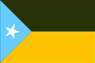 image by Ivan Sache, 30 July 2018
See also:
The municipality of Santa Clara (3,565 inhabitants in 2010; 31,000 ha) is
located in the north-west of Pastaza province, on the border with Napo province.
The municipality is made of the urban parish of Santa Clara (1,312 inh.) and of
the rural parish of San Josķ (2,253 inh.).
Santa Clara, part of a
territory originally inhabited by the Kichwa, was settled in the middle of the
20th century, during the building of the Puyo-Tena road. In 1958, the Josefina
mission acquired the Santa Clara estate (c. 300 ha) from Jes·s Londo±o; the
estate was dedicated to St. Clare by SofĒa Londo±o, the owner's wife. The
mission established a school for the natives in the Platua estate and planted
the first coffee groves.
In 1964, Santa Clara, eventually served by the road,
had a school and an hospital. The parish of Santa Clara was established on 29
December 1966.
The municipality of Santa Clara was established by a law
enacted on 2 January 1992 and published in the Ecuadorian official gazette, No.
844.
https://www.santaclara.gob.ec/
Official website
Ivan Sache, 30 July 2018
The flag of Santa Clara is horizontally divided green-yellow with a celestial
blue triangle at hoist, charged with a white star. Green represents the
exuberant forest resources and the local flora. Yellow represents the mining
resources and the diversity of products
supplied by the tropical soil.
Celestial blue represents the sky and the rivers that water, decorate and
embellish the canton, converted in beautiful bathing resorts.
https://www.santaclara.gob.ec/index.php/2014-12-11-13-47-21/simbo
Official website
Video
https://www.youtube.com/watch?v=f9oMEuTydkE (4'30")
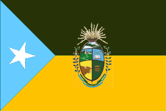 image by Ivan Sache, 30 July 2018
The flag is also used with the municipal coat of arms.
Photos
http://www.comaga.org.ec/
https://pbs.twimg.com/media/DUe8mbOXcAAQ9im.jpg
https://pbs.twimg.com/media/DUe4XBwX0AAF0kc.jpg
The coat of arms is
a vivid representation of the values, constant struggle and original liberty of
a people immersed in development and of the progress of hard-working, gentle and
kind people, represented by several elements.
The shield is surmounted by
the sun raising from a typical piece of Kichwa pottery known as "mocahua" and
surrounded by a fructed branch of coffee (left) and a branch of "guayusa"
(right). Guayusa (Ilex guayusa Moes.) is an evergreen tree cultivated
in Napo and Pastaza provinces' forest gardens; guayusa tea is a Kichwa ritual
beverage (see
https://news.nationalgeographic.com/news/2014/07/140703-guayusa-ecuador-amazon-health-foods-tea/,
National Geographic, 4 July 2014). Beneath the shield, a scroll horizontally
divided green-yellow-celestial blue (the colors of the municipal flag) is
inscribed with "CANTėN SANTA CLARA" in black letters.
The shield is
divided in five quarters.
The top quarter features river Anzu. The upper left
quarters shows the parish church. The upper right quarter features a book
surmounted by two traditional hunting blowguns - "pucuna" and "bodequera" -
crossed in saltire.
The lower left quarter represents cattle-breeding. The
lower right quarter features an "ashanga", a traditional basket used by the
natives
to carry and store food.
In base the vertical division of the
shield ends in an arrow, forming a lance.
https://www.santaclara.gob.ec/index.php/2014-12-11-13-47-21/simbo
Official website