
Last modified: 2021-12-11 by ian macdonald
Keywords: santa catarina | sangão |
Links: FOTW homepage |
search |
disclaimer and copyright |
write us |
mirrors
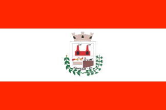 image by
Ivan Sache,
7 November 2021
image by
Ivan Sache,
7 November 2021
The municipality of SanvÐo (10,402 inhabitants in 2010; 8,306 ha) is located
170 km south-west of Florianµpolis.
SangÐo was established as the
district of 24 de Outobro by State Decree No. 531 issued on 2 March 1934,
separating from the district of Jaguaruna, and inaugurated on 2 April 1934. It
was renamed to SangÐo by State Law No. 86 promulgated on 31 March 1938.
The
municipality of SangÐo was established by State Law No. 8,552 promulgated on 30
March 1992, separating from Jaguaruna.
SangÐo is still known locally
under the name of Rua do Fogo (Fire Road). In the past, tropeiros used to spend
the night in a pottery workshop where they lit a fire, so that their meeting
point was soon known as Fire Road.
http://www.sangao.sc.gov.br/
Ivan Sache, 7 November 2021
A horizontal triband, red-white-red, 1-2-1, with the municipal shield in the centre.
Official website at
http://www.sangao.sc.gov.br
Dirk Sch—nberger,
2 August 2012
The flag is composed of two red stripes and one white.
Red
symbolizes fire ["fogo"], which gave its name to the original Rua de Fogo, now
SangÐo.
White is a symbol of peace and municipal progress.
The coat of
arms features the following elements
- Chimneys, representing industry.
-
Stone, source of income for the population.
- A laborer and a plow,
representing agriculture, a main part of the municipal income.
- Cassava and
tobacco plants, representing the main crops.
- A crown, representing the
three powers: Legislative, Executive and Judicial.
https://camarasangao.sc.gov.br/simbolos-municipais-de-sangao
Municipal
website
Photo
https://www.facebook.com/PrefeituraSangao/photos/207216808005806
Ivan Sache, 7 November 2021