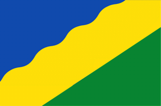
 image located by Valentin Poposki, 8 October 2019
Last modified: 2019-11-16 by rob raeside
Keywords: waadhoeke |
Links: FOTW homepage |
search |
disclaimer and copyright |
write us |
mirrors
 image located by Valentin Poposki, 8 October 2019
There is a new municipality in the Province of Friesland - Waadhoeke,
proclaimed on 01.01.2018. It consists of the former municipalities of
Franekeradeel, het Bildt, Menameradiel and parts of Littenseradiel, which all
were dissolved on the same date.
Vanja Poposki, 8 October 2019
The municipality of Waadhoeke (31,526 ha; 46,039 inhabitants in 2019) forms
the north-western corner ("hoek") of Friesland watered by the Wadden Sea. The
name of the municipality is an hybrid between Frisian (De Waadhoeke) and Dutch (Waddenhoek).
The municipality is composed of 41 nuclei, with Franeker / Frjentsjer (12,771
inh.).
The flag represents the Wadden Sea and the undulating coast of the
"hoek". The white stripe represents the dam, while green represents the land
protected by the dam. The design of the flag recalls the flag of the historical
district of Westergo / Westergoa.
The colors
are the main colors of the flag of the former municipalities
merged to form
Waadhoeke:
- Barradeel
-
Franeker
-
Franekeradeel
- Menaldumadeel
-
Hennaarderadeel
- Het
Bildt
The "wimpel" is composed of a square version of the flag with
two vertical blue and white tails, used for the "wimpel" of all municipalities
that belonged to the Westergo historical quarter.
Source:
https://docplayer.nl/21808878-Ontwerp-voor-een-wapen-vlag-en-wimpel-voor-de-nieuwe-gemeente-waadhoeke-fryske-rie-foar-heraldyk.html
Fryske Rie foar Heraldyk. Ontwerp voor en wapen, vlag an wimpel voor de
nieuwe gemeente Waadhoeke.
Ivan Sache, 11 October 2019