This page is part of © FOTW Flags Of The World website
Lupércio, São Paulo State (Brazil)
Last modified: 2013-04-27 by ian macdonald
Keywords: sao paulo | lupércio |
Links: FOTW homepage |
search |
disclaimer and copyright |
write us |
mirrors
 image by Ivan Sache, 20 April 2013
See also:
About the Flag
The municipality of Lupércio (4,353 inhabitants in 2010; 15,503 ha) is
located 40 km of Marília and 350 km of São Paulo. The municipality is
made of the town of Lupércio proper and of the district of Santa
Terezinha.
Lupércio is named for Dr. Lupércio Fagundes (d. 1937), who offered in
1926 a plot to establish a new settlement. He cleared the forest and
build the first roads with the help of Antônio Daun. The district of
Santo Inácio was established by Law No. 2,654 of 16 January 1936, as
part of the municipality of Garça, and renamed Lupércio by State
Decree-Law No. 14,334 of 30 November 1944.
The municipality of Lupércio was established by State Law No. 2,456 of
30 December 1953 and inaugurated on 1 January 1955.
http://www.prefeituralupercio.sp.gov.br - Municipal website
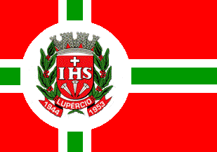
The flag of Lupércio is red with a white-green-white (1:2:1), off-
centered cross. Over the intersection of the cross' arms is placed a
white disk charged with the municipal coat of arms.
http://www.prefeituralupercio.sp.gov.br/simbolos.htm - Municipal
website
Image is a reconstruction; no original seen.
Ivan Sache, 20 April 2013

 image by Ivan Sache, 20 April 2013