![[Netherlands Antilles flag]](../images/a/an.gif) (2:3)
image by Mark Sensen, 9 November 2003
(2:3)
image by Mark Sensen, 9 November 2003
Last modified: 2021-08-25 by rob raeside
Keywords: netherlands antilles | nederlandse antillen | dutch realm | netherlands | antilles |
Links: FOTW homepage |
search |
disclaimer and copyright |
write us |
mirrors
![[Netherlands Antilles flag]](../images/a/an.gif) (2:3)
image by Mark Sensen, 9 November 2003
(2:3)
image by Mark Sensen, 9 November 2003
Official Name: Netherlands Antilles
(Nederlandse Antillen)
Previous Name: Curaçao and Dependencies
Capital: Willemstad
Location: Caribbean
Government Type: Part of the Kingdom of the
Netherlands with Full Autonomy in Internal Affairs
Flag adopted: 1
January 1986
ISO Code: AN (code transitionally reserved for 50
years)
Dissolved: 10 October 2010
See also:
The postal administration of the Netherlands Antilles issued
(30 June 1995) six new stamps with the flags and the coats of
arms of the islands. The islands consist out of: Curaçao,
Bonaire, St Maarten, Saba and St Eustatius. Only the last islands
don't have a flag and coat of arms of their own. St Eustatius
uses the flag and coat of arms of the Netherlands Antilles as its
national symbols. The Postal Service of the Netherlands Antilles
issued the booklet 'Flag Issue 1995 / Vlaggenserie 1995'
with full details on the history and use of the national symbols
of the islands.
Jos Poels, 4 August 1995
According to Album 2000 [pay00]
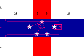
- Netherlands Antilles - The flag of the Netherlands Antilles is
white in proportions 2:3, on the center of the length a red
vertical stripe, and on the center of the height a blue
horizontal stripe across the red stripe. The width of both
stripes is one-third of the flag height. On the center of the
blue stripe are five white five pointed stars. The diameter of
the imaginary circle inscribing a star is one-fourth of the
height of the blue stripe. The colours red, white and blue refer
to the Dutch flag, the five stars symbolise the five islands.
Adopted by Country-Order of 31 December 1985, coming effective 1
January 1986. The First Flag was
adopted by Country-Order of 19 November 1959, and had six stars.
One star was dropped because Aruba left in
1986.
The centre of the topmost and bottommost stars are located at two
imaginary horizontal lines. The first line at one-sixth of the
height of the blue stripe under the upper edge of the blue
stripe, the second line at one-sixth of the height of the blue
stripe above the lower edge of the blue stripe. The centre of the
topmost star is located at the centre of the first imaginary
line. The centres of the bottommost stars are located on the
second imaginary line at such a way, that an isosceles triangle is
formed with the centre of the topmost star, with an angle of 45
degrees at the top. The centre of the leftmost star is located by
forming another isosceles triangle with the centre of the topmost
star and the centre of the left star at the bottom, again with an
angle of 45 degrees at the top. Likewise the centre of the
rightmost star is located.
Mark Sensen, 1 and 2 November 2003
Officially lowering the Netherlands Antilles' flag (videos):
http://nos.nl/artikel/190274-101010-ontmanteling-nederlandse-antillen.html
Jan Mertens, 11 October 2010
 image by Željko Heimer, 5 November 2003
.gif) image from Ralf
Hartemink site
image from Ralf
Hartemink site

Habitat Curaçao Seahorse Flag
image from www.habitatdiveresorts.com

Habitat Bonaire Pirate flag
image from www.habitatdiveresorts.com
On www.uitgeverijwvdoever.nl (defunct) was a flag without any explanation,
just "Habitat Curaçao - Curaçao, Netherlands Antilles". At www.habitatdiveresorts.com/Curaçao
the same flag and an advertisement for a local resort, aiming to keep diving
clean. At www.habitatdiveresorts.com
the flag is waving, along with a kind of pirate flag, and a bit
of info: "Capt. Don Stewart, founder of Habitat, is
recognized worldwide as a leader in the movement to protect our
underwater environment. Shortly after arriving on Bonaire in May
of 1962 he opened the island's very first dive operation. In 1977
he created Capt. Don's Habitat and pioneered the "Diving
Freedom" concept which each year continues to further
Habitat's reputation for providing fun, safe and innovative dive
vacations."
The pirate flag is the flag of Habitat Bonaire.
Jarig Bakker, 10 June 2003
Red background with descending white sword diagonally (common
part of both flags) surely makes me think of scuba diving and
snorkeling.
António Martins, 12 June 2003
According to this WMO
page the Netherlands Antilles use the well-known US signal set but with local
differences.
- 40a (red pierced black): "Gale warning: winds 39 miles an
hour (34 kt) and upwards." The only signal used on Curaçao,
Aruba, and Bonaire.] Also used on St. Maarten, Saba, and St.
Eustatius were it means something else: "Whole gale warning:
winds within the range 55 to 73 miles an hour (48 to 63
kt)."
Further St Maarten, Saba, and St Eustatius signal flags:
- 41a (double set of red pierced black): "Hurricane warning:
winds 74 miles an hour (64 kt) and upwards."
- 39a (double set of red pennants): "Gale warning: winds
within the range 39-54 miles an hour (34-47 kt)."
- 56a (red pennant): "Small craft warning: winds and seas or
sea conditions are only dangerous to small craft operations.
Winds range up to 38 miles an hour (33 kt)."
I suppose the difference in use is climatologically justified.
Jan Mertens, 16 March 2008